Professor in Residence, Department of Architecture, GSD, Harvard University, Cambridge MA, USA
Policy
Open Access
Type
Article
ABSTRACT -
Addis Ababa, Ethiopia’s capital city, is currently experiencing an unprecedented population boom and subsequent rapid urbanization which has fostered internal imbalances within the city’s urban landscape. To this should be added the negative effects derived from the continued impacts of a changing global climate. Together, these combined consequences have compromised the sustainable development of Addis Ababa. This essay addresses the initial outcomes of the “Addis Ababa River City” research project, an academic program created to address these aforementioned challenges through a holistic urban resilience strategy and design methodology. To do this, the research project proposes the use of a sustainable infrastructure as the primary design intervention, where the existing ecological elements serve as the foundational backbone but also include other urban dimensions. This paper will elaborate on the design methodology and resulting sustainable infrastructure intervention in two different and nested scales, the upper region of the Kebena river and Peacock Park. Together, this body of work demonstrates how to elucidate a holistic understanding of the complex urban realities that Addis Ababa, and many other growing worldwide metropolises, face today and into the future.
Ethiopia and its capital city of Addis Ababa are currently experiencing an unprecedented population boom. In the last two decades, the country has doubled in its number of inhabitants to now stand at around 114 million citizens.1 This figure places Ethiopia as the 12th most populous country across the globe. In parallel, Addis Ababa has also experienced growth similar to that of the country at large (Table 1).2
Table 1.
1
| Population | 15.000 | 80.000 | 402.015 | 455.490 | 683.530 | 1.423.182 |
| Year | 1889 | 1930 | 1952 | 1961 | 1967 | 1984 |
| 2.112.737 | 2.739.551 | 3.433.999 | 6.156.000 | 13.212.000 | 23.709.000 | 35.820.000 |
| 1994 | 2007 | 2017 | 2025 | 2050 | 2075 | 2100 |
Addis Ababa, historical population and projection.
It is estimated that the city has doubled its population in this millennium at a range between 3.6 and 4.4 million inhabitants,3 with recent annual growth rates between 3% and 3.8%.4 Future growth forecasts are similar to these current numbers and both Ethiopia and Addis Ababa are expected to double in population in the coming years. By 2050, Ethiopia will be one of nine countries that will concentrate more than half of the world’s population increase.5
Contrary to this population boom, Ethiopia continues to be one of the least urbanized countries in Africa.6 Even with continued population growth, the latest official predictions state that the country’s urbanization is only around 20% of the total.7 However, the effects of increased urbanization can be seen in the change of the land-cover plan of Addis Ababa over the past few decades. This is especially evident over the last few years wherein the capital city has seen its built area increase by more than 50 percent (Fig. 1).8

Figure 1.
1
Diagram of urbanization of Addis Ababa.
Unfortunately, the rapid growth of Addis Ababa has fostered internal imbalances and compromised the city’s sustainable development. The city has experienced uneven physical expansion, wherein the consumption of urban land has been greater than its population growth.9 For example, in the city center there are peak areas with urban densities of 30.000 people per km2 [11,583 people per sq. mi.], reaching 30% of the population in just 8% of the total urban land.10 In contrast, 46% of the area metropolitan is underused, or even empty,11 and the city’s density of people per hectare decreased from 194 in 2000 to 136 fourteen years later.12 All these statistics help to understand the current tendency towards low density and peripheral physical growth, fragmented development, and limited mixed-use
areas. Furthermore, the rapid physical growth of the city has not been accompanied by a development of the urban infrastructures necessary to accommodate the basic services of the new population.13 These basic infrastructures include, but are not limited to, public water and waste management services, housing and facilities, security and ecology, mobility and energy, and economic and educational opportunities.14
To this should be added the negative effects derived from the impact of climate change. Both the country and its capital are experiencing climate change effects through an increase in average temperature and the alteration of rain cycles (Table 2).
Table 2.
2
| Temperature Anomaly (C°) | +0.6 to 1.5 (+1.0 °C) | +1.2 to +2.6 (+1.8 °C) | +2.1 to +4.0 (+2.8 °C) | +2.8 to +5.5 (+3.7 °C) |
| Precipitation Anomaly | -14.4 to 21.2 (+2.2 mm) | -16.8 to +27.4 (+3.1 mm) | -18.8 to +37.6 (+6.0 mm) | -17.5 to +50.0 (+9.7 mm) |
| Projection | 2020-39 | 2040-59 | 2060-79 | 2080-2099 |
Climate data projections for Ethiopia.
Ethiopia’s temperature is expected to increase by a total of 1,8ºC [35.2ºF] by 2050 and 3,7ºC [38.7ºF] by the end of the century.16 While the predictions about rainfall are uncertain, it is estimated that an 18% increase in extreme weather events (droughts and heavy rains) is expected in the near future.17 Together, this makes Ethiopia one of the most vulnerable countries to climate change due to its high dependence on sectors that are most affected by a changing climate, including agriculture, transport, energy, and continued impacts on an already inadequate urban infrastructure.
The combined effects of rapid urbanization derived from increased population growth and climate change have compromised the sustainable development of Addis Ababa. The city’s rapid urbanization is degrading and minimizing urban ecologies, thereby compromising the cycles and functions of these ecosystems. The degradation of the natural ecosystem within the urban environment increases the problems of the systems that city dwellers depend on, which are already inadequate for the current population. In other words, the effects of population growth, urbanization, and climate change are creating a vicious cycle that is minimizing “the resilience to stress and shocks of the whole urban system” and worsening “the likely impacts of climate change-related hazards on the city.” 18
The “Addis Ababa River City” research project has been created to address the aforementioned challenges through urban and architectural design. The main objective is to design a holistic urban resilience strategy for Ethiopia’s capital.19 This essay shows the initial outcomes of the research project and is divided into four different sections. The first section defines the relationship between the city and its water bodies to set the general approach and design strategy. Next, a polyhedral analysis at different scales serves to diagnose the most urgent urban issues present within Addis Ababa. The third section addresses these urban issues through a holistic urban strategy for a specific city sector, a sustainable infrastructure for the Upper Kebena river watershed. Finally, a specific architectural intervention for one of the most urgent and significant locations within the sustainable infrastructure strategy will be described in detail, a green resilience neighborhood in Peacock Park to ecologically reconnect the existing urban fabric with its natural environment.
ADDIS ABABA AS A RIVER CITY
Addis Ababa does not have one large river, but a tangle of many small rivers and streams. There are two major rivers, Great Akaki (Tiliku Akaki) and Little Akaki (Tinishu Akaki), which divide the city into two watersheds (2/3 eastern and 1/3 western respectively) and several minor rivers, Kebena, Kechene, Kurtumi, Bante-yiketu, and Bulbula, plus a large number of small streams (Fig. 2).

Figure 2.
2
Rivers and streams in Addis Ababa, with the Upper Kebena river highlighted.
In total, Addis Ababa has 607 km [377.2 mi.] of rivers that cover a combined area of over 4.000 ha [9,884 acres].20 Most of the rivers are born from the Entoto Mountains north of the city and converge towards the south of the city until they become the Great Akaki river while building deep gorges and unveiling rocky riverbeds. The morphology of the city ranges from the steep slopes close to the Entoto ridge at about 3.000 m [9,842.5 ft.] above the sea level towards a southern gentle sloping terrain at around 2.100 m [6,889.7 ft.]. These physical characteristics were pertinent to the evolution of the city as the morphology of Addis Ababa is closely linked to its topography.
The founding of Addis Ababa is intimately linked to water.21 In the late-nineteenth century, Emperor Menelik II and his wife Taitu moved the royal residence to the Entoto Mountains due to its strategic position within the mountain valley. The existence of hot springs on the slopes of the mountain range (in a fertile and warm land area known then by Filwoha) aroused the interest of other royal family members and high-ranking officials to the point of relocating their own residences (Fig. 3a). Residences, spas, and bathhouses began to proliferate in the areas around these sources of thermal water. In 1887, Emperor Menelik II officially founded the new capital of the country and named it Addis Ababa, or “New Flower” in Amharic.
In this spot, with my father, Sahle Sellassie, surrounded by a fence: go there and begin your house. Once, in this very place Sahle Sellassie, like the prophet Mikias, made the following prophecy. One day, as he sat under that great tree not far from Mewat [Mai heywot, or “water of life,” a reference to the hot springs] mead, was brought to him while he was playing chess as was his custom. Suddenly he said: “Oh land, today you are full of Gallas, but the day will come when my grandson will build here a house and make you a city.” 22
Despite this physical and historically close relationship, the city has turned its back on the rivers and streams that flow through it (Fig. 3b).

Figure 3.
3
(a) The hot springs at the foot of the Imperial Palace at the beginning of the nineteenth century; (b) Addis Ababa’s rivers situation nowadays.
Today, most rivers are used primarily as a waste evacuation system, where municipal, human, and industrial waste is dumped without any prior treatment.23 Some riverbanks have become severe flood-prone areas that threaten the surrounding built environment where many low-income settlements are located.24 Once cherished, pollution and flood-risk have now left the rivers and river-banks undesirable — a reality that extends to the urban areas surrounding them. Continued population growth and urbanization will continue to exacerbate the uncontrolled expansion of popular settlements in the riverbanks, constant climatic changes will increase the frequency of severe flooding events, and continued pollution of the river system will perpetuate the devaluation of the rivers and riverbanks and threaten public health.25
Due to the close historical and physical relation between Addis Ababa and its rivers, the “Addis Ababa River City” research project proposes to use the rives as the main element to tackle the current urban issues of the city.26 This approach is paramount for a variety of reasons. One, the rivers remain an essential source for potable water, washing, and bathing for a large part of the Addis Ababa population who still lack basic utilities and services. River restoration will help in obtaining clean drinking water and mitigating the spread of water-borne diseases. Two, many of Addis Ababa’s most at-risk citizens reside in the flood-prone areas of the riverbanks, posing a serious public safety concern to the city. Adaptation of the built environment within these flood-prone areas will dramatically improve the safety and security of city inhabitants during flood and drought events. Three, the recovery of the rivers and the riverbanks will also recover some of the most important ecological systems of Addis Ababa. Hence, the city will maximize its resilience to the extreme events derived by climate change and relieve some of the currently inadequate urban systems. Lastly, the urban form of Addis Ababa is strongly characterized by its topographical and geographical features. Utilizing the tangle of rivers would serve as one of the most effective ways to access and traverse a majority of the city. Thus, the restoration of the rivers will allow the inclusion of a sustainable strategy that will help to activate and reconnect the urban context in a social, cultural, and economical manner. In essence, the rivers will be restored to their former distinction as a prominent civic feature within Addis Ababa.
The Upper Kebena River
The research program has selected a specific area to locate its initial holistic urban resilience strategy for Addis Ababa: the upper region of the Kebena river. This river is part of the Big Akaki’s catchment, one of the two watersheds that divide the city. The Kebena river is born from the Entoto Mountains north of the city and then moves downhill until it merges with the Akaki river south of the city. In its initial stretch high in the mountain range, the Kebena river has a large number of small tributaries. These tributaries are born from different mountain points and are then incorporated into the main river body at the first stages of its urban route.
The Kebena river is one of the longest rivers in the city. Although, this proposal will be limited to the upper part that runs from its source in the Entoto Mountains to Peacock Park in the city’s central urban core. Therefore, the project will be focused on the central-north part of Addis Ababa and will join different sub-cities within its watershed (Bole, Kirkos, Arada, Yeka and Gulele). This geographical location determines a heterogeneous character to the area studied, from a high dense urbanscape to an open and natural one. The location selected helps to underline the infrastructure’s ecological conception as a “green-blue corridor” that introduces multiple ecological wedges from the mountain to the center of the city.
ADDIS ABABA’S MOST URGENT URBAN ISSUES
The “Addis Ababa River City” research project has sought to engage a polyhedral and multi-scale analysis of Addis Ababa’s current urban situation. For that reason, the causes and origins of the present urban issues were examined from many sources and perspectives — history and demographics, urban ecologies and climate, infrastructures and mobility, socio-economics and governance — and scales — country, metabolic region, and city — with a critical approach. Research at the country scale consisted of compiling data points on population demographics, migration patterns, ethnic and religious demographics, employment and locations of various modes of commerce. Research into the rich and complex history of Ethiopia was also investigated. Between the country scale and the metabolic region, the ecological systems and specific climate data were analyzed. Concurrently, a multitude of research was conducted on Addis Ababa at the scale of a city. These data points included tabulating sites of historical and cultural relevance, places of civic importance, urban social and economic hubs, infrastructure systems, modes of transportation, and a holistic analysis of the existing citywide ecologies.27
Once compiled, the data was then synthesized graphically into a series of maps and associated graphs, charts, and timelines (Fig. 4).

Figure 4a.
4
Analysis of Urban Ecologies.

Figure 4b.
42
Analysis of Production and Commercial areas.
These conceptualized catalogs allow for the intertwining of different layers of data to uncover profound links, new readings, and a more holistic understanding of the complex urban realities faced at a country and city scale. This methodology of data compiling, graphical layering, and mapping analysis uncovered five urgent urban issues that affect the resiliency of both Addis Ababa and the Upper Kebena river region. These five issues include the extensive pollution of the river water in many stretches of the river and riverbanks; scarcity of drinkable water; an increase of urban flooding events with special attention to the riverbanks containing fragile settlements; generalized problems of mobility, specifically a lack of connection between the rivers and the surrounding city; and, with a main focus on the upper region of the Kebena river, a lack of basic public facilities within this area.
As a result of rapid population growth, uncontrolled urbanization and industrialization, poor waste management practices, and an inadequate and dated stormwater and sewage system, the Upper Kebena river has experienced a high water pollution rate.28 Most of the pollution can be attributed to domestic and industrial waste in the upper Kebena river area, as most of the agricultural fields are located in the South of the city, which discharge their waste into the Kebena river without any proper treatment. Simply put, the river currently serves as a dumping ground for human and industrial waste alike. Although the water supply system has been improved in the last decades, there is still a deficient and outdated potable water infrastructure that leads to low and intermittent access to potable water within Addis Ababa.29 Because of this, many low-income settlements within Addis Ababa do not have access to potable water in their homes. Instead, many of these individuals resort to using the polluted river water not only for drinking but also for clothes washing, bathing, and to irrigate certain local agricultural fields.30 This polluted drinking water leads to waterborne illnesses which affect the human population, livestock, and crops grown in certain urban farming areas of the city.
Flooding is another important challenge for Addis Ababa (Fig. 5).
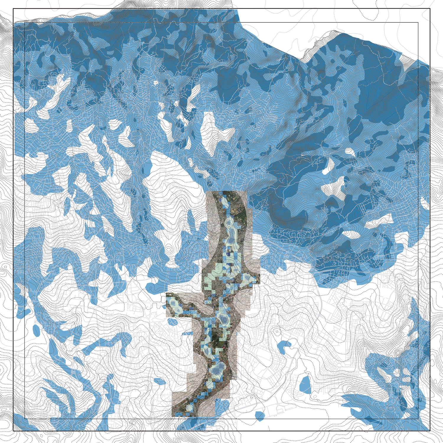
Figure 5.
5
A flooding analysis of the Upper Kebena river area.
In this case, the reasons are diverse as well as the consequences. The topography of the city, with steep slopes in the Northeast and low-lying floodplains in the Center-South, is prone to flooding situations. Moreover, extreme weather events provoked by climate change will exacerbate the already heavy rainfall during the Kiremt rainy season in the late summer.31 The rapid growth of the city has brought to light the inadequacies of an outdated drainage system and has further reduced the existing green spaces that serve as natural stormwater drainage spaces. This same urbanization has increased impervious urban surfaces, which create severe flooding events during storms. Also, rapid population growth has displaced lower-income residents to flood-prone areas, so the space for the natural dynamics of the rivers has been decreased while compromising the integrity of these fragile settlements.32
The current mobility network does not meet the needs of the current population in Addis Ababa. The rapid outward sprawl of the city over the last decades has dramatically increased travel distances. Unfortunately, the existing public transportation system has not been developed enough to accomplish the residents’ growing needs to traverse the city quickly and efficiently. This situation causes a growing demand for private vehicular transport which amplifies the current traffic congestion and increases carbon monoxide emissions. Walking still remains as the main transportation mode for most city dwellers, where approximately 54% of inhabitants travel by foot.33 However, Addis Ababa has little to no pedestrian-friendly infrastructure, as only 14% of the main roads have safe pedestrian sidewalks.34 Moreover, the rivers themselves have become a barrier for intercity travel. Many streets, and the few pedestrian pathways that currently exist, often abruptly stop at the riverbanks. This lack of connectivity is highly present between the existing housing settlements that dot the riverbanks of the Upper Kebena river. Severed paths, streets, and a lack of bridges has led to a multitude of neighborhoods being wholly disconnected and isolated from each other.
All these urban problems have caused the city to turn its back on the rivers and its adjacent areas. This neglect has led to a lack of basic public facilities within these urban areas, such as schools, health care centers, water, sewage and waste infrastructures, or public housing and spaces. Unfortunately, this civic neglect and resulting scarcity of resources is prevalent in most watersheds of the city. However, it is especially significant in the Upper Kebena river watershed due to the existence of many popular settlements on its riverbanks and the dissolution of the city in the Northeast zone.
A SUSTAINABLE INFRASTRUCTURE FOR THE UPPER KEBENA RIVER
After diagnosing the five most urgent urban issues along the Upper Kebena river, a speculative redesign of the surrounding environment was proposed to address these ailments. To do this, the “Addis Ababa River City” research project proposes the use of a sustainable infrastructure as the main design strategy, where the ecological components are the foundational elements but also include other urban dimensions (architectural, social, cultural, economic, energetic...). Thus, the redesign introduces a sustainable infrastructural framework that uses the own river as the proposal’s fundamental element, but it also extends its ratio of action to the closest neighborhoods and the rest of the city. This sustainable infrastructure will help to create a more resilient city, giving Addis Ababa the tools needed to holistically tackle current and future urban issues. Essentially, the sustainable infrastructure consists of an urban palimpsest that overlaps and connects three layers (Fig. 6): ecology, the recovery of the rivers and riverbanks; opportunity, the promotion of zones of activity and connection of points of interest; and connectivity, the creation or modification of axial and transversal mobility networks to reconnect to the river. Thus, the proposal creates a constellation-like infrastructure which helps to sew the city together from different ecological and urban perspectives along the Upper Kebena river watershed while establishing the basis for a more resilient city.
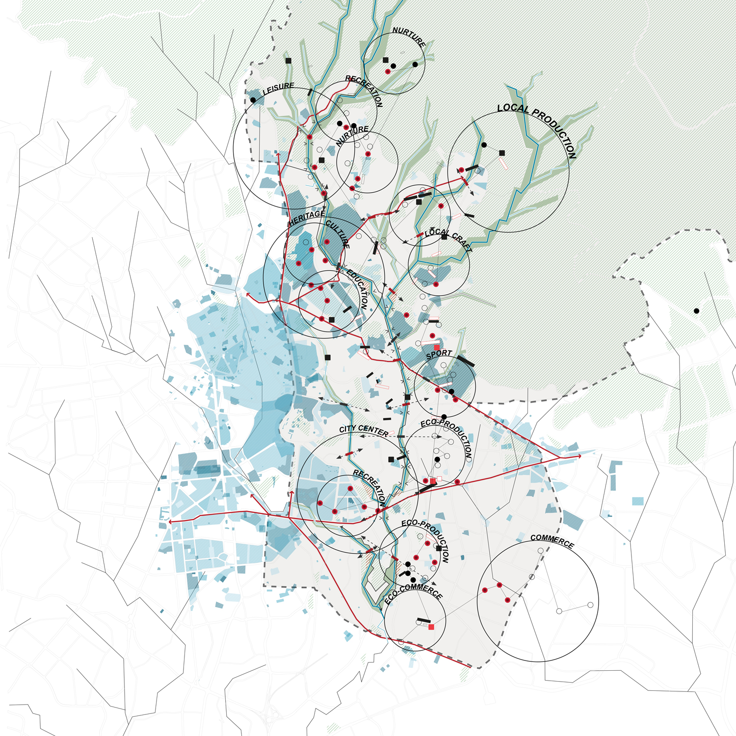
Figure 6.
6
The new Upper Kebena river sustainable infrastructure.
The base layer of the proposed sustainable infrastructure is the ecology (Fig. 7a). The basic element of this layer is the upper region of the Kebena river which creates a main vertical North-Center axis with secondary branches to the Northeast. Therefore, the main intervention within this layer is the recovery of the river and its riverbanks. Due to the lack of available large surface areas around and on the riverbanks, this layer proposes a nature-based system of multiple, small and mixed interventions to clean the water, control flooding events, manage the removal of human and industrial waste. For example, the design proposes the construction of wetlands adjacent to existing bridges to clean the spill from the sewage channels and run-off water before reaching the river. Other interventions include giving space back to the rivers to control flooding and repurposing these spaces for a multitude of productive functions like urban agriculture or small public water facilities (detention ponds, irrigation channels). Moreover, the recovered river provides open public space for a new linear park that includes a slow mobility network in both the vertical and transversal axis. Thus, the infrastructure proposed in this layer reconnects the different parts of the existing city along the upper Kebena river, introduces the Northeast sector of natural landscapes to the city center, and establishes a multitude of new ecological, recreational, and productive landscapes.
Next, the opportunity layer is structured alongside the ecological one. This opportunity layer can be divided into two different scales, the city and the neighborhood scale (Fig. 7b). At the city scale, “ripples of influence,” are introduced which include the pre-existing socio-economical and historical hubs of Addis Ababa. These ripples help to identify the character of the main zones within the upper part of the Kebana river and establish the principal coordinates of the new mobility network. At the smallest scale are the sites that depict optimal places for architectural or urban intervention. These opportunity sites are selected based on availability within a neighborhood, either being open plots or underused structures close to the river. These sites also serve to anchor the slow mobility network as established in the ecological layer.
Specific interventions such as public housing, public restrooms, waste-water management infrastructure, marketplaces, public spaces, schools, healthcare centers, or transportation hubs are introduced into these sites depending on location and programmatic adjacencies. For example, one such ripple of influence is home to a large primary and secondary school campus. In this instance, the sustainable infrastructure proposes a recreational area, health center, and/or vocational school. The idea is that these interventions would complete, enhance, and connect the current program of space to the currently detached settlements that are located nearby, helping to reinforce a sense of community. The place and programming of these interventions serve to build more self-sufficient neighborhoods while promoting a more compact, continuous, and mixed-use city model for Addis Ababa.
Finally, the third layer is related to multimodal connectivity (Fig. 7c). This layer proposes the modification of the existing mobility network as well as the creation of new mobility routes. New hubs, or transit stops, serve as the connection spots between the existing, reconfigured, and proposed mobility routes. The new network’s most important element is the linear park along the upper Kebena river and its main streams within the center-northeast corridor. The larger-scale lines of the linear park serve as the connective tissue between the principal “ripples of influence.” These lines represent the existing main avenues of travel that could benefit from specific modifications. One such modification is a proportional reduction of the number of lanes for private vehicles to increase urban space that can be dedicated solely to public and slow mobility. These new pedestrian friendly lanes would also include green and blue systems, such as bioswales and permeable pavement, that reinforce the connection of this layer to the ecological layer.
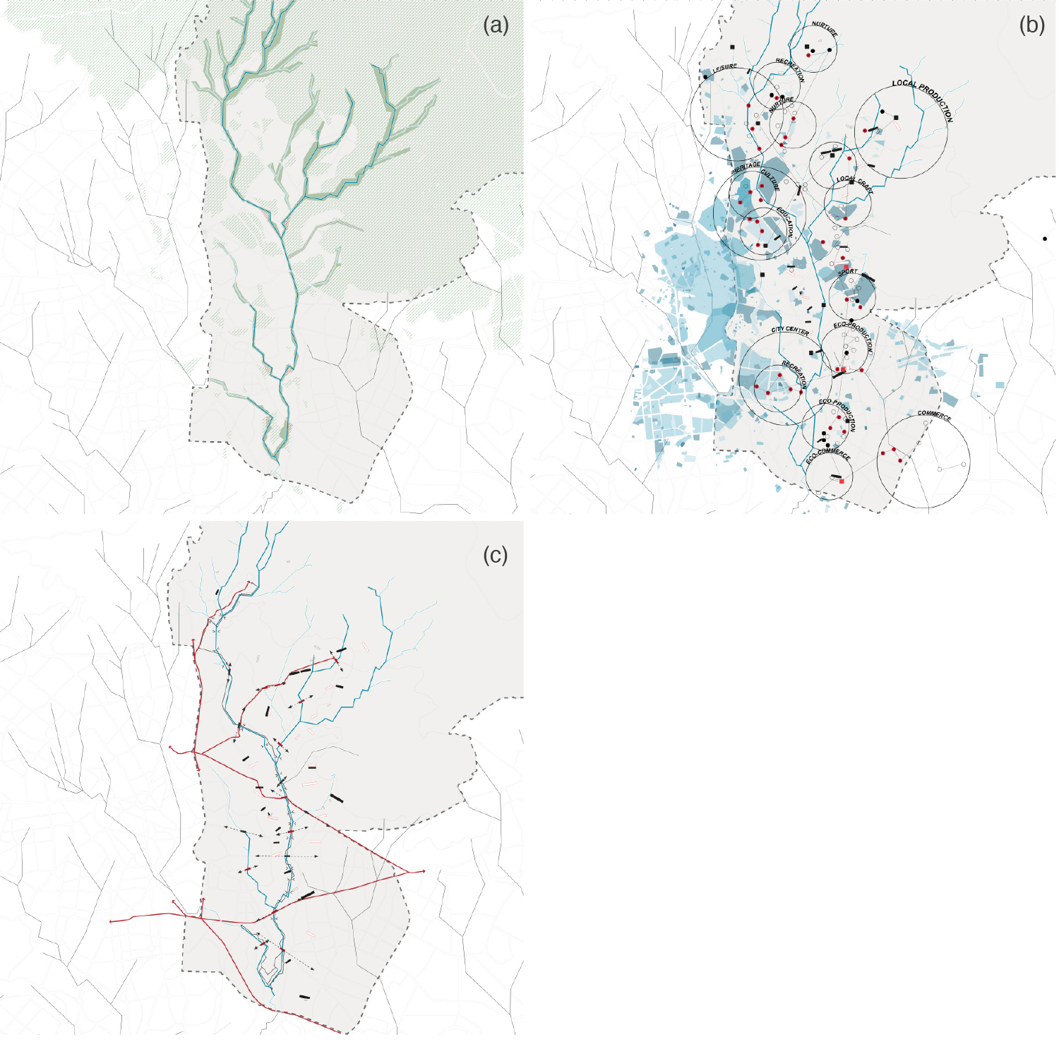
Figure 7.
7
Different layers of the sustainable infrastructure for the Upper Kebena river area: (a) Ecology, (b) Opportunity, and (c) Connectivity.
The minor lines depict mobility within the “ripples of influence” and connect the most critical opportunity sites. Some depict existing connections, such as bus routes, formal and informal paths, and footbridges. Others depict a new mobility infrastructure that reconnects once detached neighborhoods within the city. These new minor lines at the smaller neighborhood-scale continue the logic of the ecological slow mobility corridor. They extend the river and linear park inside the different neighborhoods and the city at large, like stitches stretching to weave together these detached areas to each other. These lines include smaller architectural interventions such as new pedestrian-only walkways, bridges, and streets. In all instances, the new mobility infrastructures include sustainable features such as the utilization of permeable materials, local plantings, bioswales and stormwater retention and detention ponds that double as public recreational spaces.
PEACOCK PARK, A GREEN RESILIENCY NEIGHBORHOOD
As a significant site within the sustainable infrastructure for the upper Kebena river region, the existing Peacock Park was deemed a critical location in need of a strategic intervention. Peacock Park is approximately 1,31 km [0.82 mi.] in length and is nestled between the Kebena and Bante-yiketu rivers.35 The park is utilized in a unique way due to its proximity to both the natural environment and the economic and civic vitality of downtown Addis Ababa. This juxtaposition between the natural and manmade environment creates four main functions of public space. Currently, Peacock Park is home to a gated public park, a substantial urban farming practice, a large informal marketplace, and a large popular housing settlement along the upper Kebena and Bante-yiketu rivers.
The site is also subject to all five of the major issues, as stated for the Upper Kebena region at large. The polluted waters of the Kebena and Bante-yiketu rivers are prone to annual flooding events that affect the surrounding farming and low-income housing areas. Many of the buildings present here are structurally unsafe and built directly within the flood zone. The polluted river water is also used for drinking and irrigation which creates a major public health concern. Additionally, there is but one precarious road that physically connects the site to the rest of the city center. And finally, the large urban farming practice within the park lacks adequate facilities and infrastructure to properly farm in a sustainable manner.
To address these issues, the same logic of the city scale sustainable infrastructure was utilized to redesign Peacock Park. First, research and mapping analysis shed light on the current issues plaguing Peacock Park. The dedicated park space often goes unutilized and unnoticed due to a lack of paths and bridges to provide public access. Crop production and the health of the urban farmers are constantly at risk due to the polluted waters used for irrigation. Water-borne diseases negatively impact the health of farmers, their cattle, and the crops they produce.36 The popular settlements within the park are comprised of structurally inadequate homes that were built within the flood zone of the Kebena and Bante-yiketu rivers. These popular settlements have existed for decades and the communities there face a multitude of health and safety concerns living in such close proximity to polluted river water.37
In response to these problems, a specific sustainable infrastructure to Peacock Park was established to transform the site into an ecologically resilient community (Fig. 8).

Figure 8.
8
Proposal for the new Peacock Park neighborhood.
To address flooding, water retention ponds and a vegetated slow water filtration system were designed into the floodplain zone as a perimeter first ring. This first ring of defense serves as a vegetated buffer between the built area and the floodplain. The slow water filtration system moves the river water through an engineered system of channels that include native plantings and soils. This system removes heavy metals and other pollutants in an environmentally friendly manner to help purify the river water. Moreover, these native plantings placed in this first ring help enrich the soil’s carbon content, thereby enhancing the land’s productivity. From here, the sustainable infrastructure moves into ring two, where the existing farming plots are reorganized along a series of gabion walls. These gabion walls extend from the riverbanks out into the farming plots, diverting the treated river water into the farming land as a means of natural irrigation.
Moving further uphill from the river, ring three is encompassed by a series of footpaths and small bridges. This new circulation network connects the farming plots to the new residential neighborhoods housed within ring three. Now further uphill from the river’s flood banks, new affordable housing units are built atop stilts above the ground plain in order to mitigate the detrimental effects of flooding. These new housing units are mainly destined to relocate the people from the prone flooding settlements, so they can still live in the same area. This zone also repurposes underperforming farming plots and vacant residential lots into local community gathering spaces – to include communal gardens, outdoor kitchens, and potable water access. These small communal spaces help to stitch together the new and existing housing units to create a more accessible and equitable residential community. New covered marketplaces, greenhouses, and farming supply depots serve as the small architectural interventions that weave the site’s activities together — farming, habitation, and commerce.
Finally, the central ring of the masterplan includes the redesigned public park space. The new Peacock Park serves as the ‘backyard’ to the new housing units. A multitude of scenic walkways serves as the access points into this new public space from various points within the city center. Together, the combination of the flood protection landscape plan and enhanced residential and urban farming infrastructure creates a Peacock Park that can withstand seasonal flooding, clean its polluted waterways, sequester carbon into the soils used for farming practices, and enhance the social engagement within the existing residential settlement.38 This new Peacock Park could serve as the model resilience neighborhood wherein architecture can help to highlight the urban public green spaces, create safer and more equitable residential settlements, and enhance the vitality of urban farming and the local economy.
CONCLUSION
The future indeed presents a series of challenges for Addis Ababa, but also opportunities to create a more resilient city. The research presented here strives to find a sustainable solution to accommodate the complexity of urban issues that plague Addis Ababa. Unlike other approaches to address the urban issues in rapid growth cities, this design focuses on a feature prevalent in almost all global cities: rivers and river systems. River restoration and adaptation within their respective urban context is the most effective way to create “sustainable systems” in which ecological, social, cultural, and economic value can be injected into a person-focused city. While the resultant design work in this essay narrowed its focus to the Upper Kebena river watershed, the comprehensive and layered research methodology presented allows for sustainable infrastructure implementation throughout Addis Ababa. Other rivers and river systems within the city could adopt this methodology as they have similar conditions and common urban issues. Furthermore, this methodology and resultant sustainable infrastructure plan can serve as a new framework for understanding and designing for resiliency in other worldwide growing metropolises, which are also facing rapid urbanization and the detrimental effects of climate change.
Notes
1
According to the United Nations, since the last official census dates from 2007 when the country had 73.75 million inhabitants. However, the United Nations raises the population to 80.67 million for that year in the same estimate and also places 66.22 million inhabitants in the year 2000. United Nations, Department of Economic and Social Affairs, Population Division, World Population Prospects 2019 (New York: United Nations, 2019), online edition, rev.1, https://population.un.org/wpp/Download/Standard/Population/; Central Statistical Agency, The 2007 Population and Housing Census of Ethiopia: Statistical Report for Country Level (Addis Ababa: Central Statistical Agency, 2010), 7.
2
The first comprehensive census in Ethiopia was obtained in 1984, as the Central Statistical Authority stated in the report of that census’s outcomes. However, some sample surveys were taken since 1961. After that, two more censuses in 1994 and 2007 have been taken until nowadays. The rest of the figures are only estimations from different authors or institutions. Central Statistical Agency, The 1984 Population and Housing Census of Ethiopia (Addis Ababa: Central Statistical Agency, 1991), 1.
3
The Central Statistical Agency estimated 3.6 million inhabitants in 2019 when the United Nations assumed a population of 4.4 million in 2018. Nevertheless, according to other researchers, a population of around 5 million is supposed nowadays as “the informal estimate is much higher than the official estimate.” Central Statistical Agency, Projected Population of Ethiopia - 2011 (Addis Ababa: Central Statistical Agency, 2019), https://www.statsethiopia.gov.et/population-projection/; United Nations, Department of Economic and Social Affairs, Population Division, The World’s Cities in 2018: Data Booklet, ST/ESA/SER.A/417 (New York: United Nations, 2018), 10, https://digitallibrary.un.org/record/3799524?ln=en; Elias Yitbarek Alemayehu, Imam Mahmoud Hassen, Yonas Alemayehu Soressa, and Laura Stark, “New Perspectives on Urban Transformation in Addis Ababa,” in The Transformation of Addis Ababa: A Multiform African City, ed. Elias Yitbarek Aemayehu and Laura Stark (Newcastle upon Tyne, UK: Cambridge Scholars Publishing, 2018), 2.
4
UN-Habitat, The State of Addis Ababa 2017: The Addis Ababa We Want (Nairobi: UN-Habitat, 2017), 12; World Bank Group, Ethiopia Urbanization Review: Urban Institutions for a Middle-Income Ethiopia (Washington DC: World Bank Group, 2015), xii, 1, 3, https://openknowledge.worldbank.org/handle/10986/22979.
5
Ethiopia is estimated to reach a population of 205 million in 2050. United Nations, Department of Economic and Social Affairs, Population Division, World Population Prospects 2019: Highlights, ST/ESA/SER.A/423 (New York: United Nations, 2019), 14, https://population.un.org/wpp/Publications/Files/WPP2019_Highlights.pdf.
6
World Bank Group, Ethiopia Urbanization Review, xii, 1, 3.
7
Central Statistical Agency estimated a rising percentage from 18.9% (2014) to 20.22% (2017). However, the United Nations estimated 19.7% in 2018, while the World Bank increased the percentage to 25% in 2015. Central Statistical Agency, Population Projection of Ethiopia for All Regions at Wereda Level from 2014-2017 (Addis Ababa: Central Statistical Agency, August 2013), 31, 118; World Bank Group, Addis Ababa – Enhancing Urban Resilience: City Strength Resilient Cities Program (Washington DC: World Bank, 2015), 9, 25; United Nations, World’s Cities in 2018, 10.
8
According to UN-Habitat, the land cover in Addis Ababa expanded from 134 km2 [51 sq. mi.] in 1999 to 201 km2 [77.6 sq. mi.] in 2014. UN-Habitat, The State of Addis Ababa 2017: The Addis Ababa We Want (Nairobi: UN-Habitat, 2017), 73-74.
9
World Bank Group, Ethiopia Urbanization Review, 47-51.
10
World Bank Group, Addis Ababa, 25, 30.
11
Ibid., 25.
12
“Addis Ababa. Density,” Atlas of Urban Expansion, accessed July 21, 2020, http://www.atlasofurbanexpansion.org/cities/view/Addis_Ababa.
13
World Bank Group, Ethiopia Urbanization Review, 50.
14
Some recent studies regarding the urban issues in Addis Ababa derived by its rapid growth included: Edmond J. Keller and Edith Mukudi-Omwami, “Rapid Urban Expansion and the Challenge of Pro-Poor Housing in Addis Ababa, Ethiopia,” Africa Review 9, no. 2 (2017): 173-85, doi:10.1080/09744053.2017.1329809; Elias Yitbarek Aemayehu and Laura Stark, eds., The Transformation of Addis Ababa: A Multiform African City. Larissa Larsen, Kumelachew Yeshitela, Tilahun Mulatu, Sisay Seifu, and Hayal Desta, “The Impact of Rapid Urbanization and Public Housing Development on Urban Form and Density in Addis Ababa, Ethiopia,” Land 8, no. 4 (2019): 66, doi:10.3390/land8040066; Mintesnot G. Woldeamanuel, Urban Issues in Rapidly Growing Cities Planning for Development in Addis Ababa (New York, NY: Routledge, 2020).
15
Paolo Billi, Yonas Tadesse Alemu, and Rossano Ciampalini, “Increased frequency of Flash Floods in Dire Dawa, Ethiopia: Change in Rainfall Intensity or Human Impact?,” Natural Hazards 76, no. 2 (March 2015): 1373-94; Bisrat Kifle Arsiso, Gizaw Mengistu Tsidu, Gerrit Hendrik Stoffberg, and Tsegaye Tadesse, “Influence of Urbanization-Driven Land Use/Cover Change on Climate: The Case of Addis Ababa, Ethiopia,” Physics and Chemistry of the Earth 105 (2018): 212-23.
16
“Ethiopia Projected Future Climate,” WBG Climate Change Knowledge Portal, accessed August 5, 2020, https://climateknowledgeportal.worldbank.org/country/ethiopia/climate-da....
17
Ibid.
18
UN-Habitat, The State of Addis Ababa 2017, 73.
19
The “Addis Ababa River City” is an academic, independent, multidisciplinary, and long-term research project lead by the Assistant Professor Dr. Ruben Garcia Rubio within the Tulane School of Architecture (Tulane University – New Orleans LA, USA).
20
Centre for Environmental Science, Addis Ababa Rivers and Riversides Development Plan Project Final Report. Part 1 (Addis Ababa: Addis Ababa University, 2017), 1.
21
Richard Pankhurst, “Menelik and the Foundation of Addis Ababa,” The Journal of African History 2, no. 1 (1961): 103-17; Fasil Giorghis and Denis Gerard, The City and Its Architectural Heritage: Addis Ababa 1886-1941. La Ville and Son Patrimoine Architectural (Addis Ababa: Shama Books, 2007); Dandena Tufa, “Historical Development of Addis Ababa: Plans and Realities,” Journal of Ethiopian Studies 41, no. 1/2 (2008): 27-59.
22
Guebre Sellassie, Chronique du regne de Menelik II, roi des rois d’Ethiopie (Paris: Maisonneuve Freres, 1931), 230, 232-33.
23
Tamiru Alemayehu, “The Impact of Uncontrolled Waste Disposal on Surface Water Quality in Addis Ababa, Ethiopia,” Ethiopian Journal of Science 24, no. 1 (2001): 93-104; Getaneh Gebre and Daniel J. Van Rooijen, “Urban Water Pollution and Irrigated Vegetable Farming in Addis Ababa,” in Water, Sanitation and Hygiene - Sustainable Development and Multisectoral Approaches: Proceedings of the 34th WEDC International Conference, ed. Rod Shaw (Loughborough, UK: Loughborough University, 2009): refereed paper 166; Hamere Yohannes and Eyasu Elias, “Contamination of Rivers and Water Reservoirs in and around Addis Ababa City and Actions to Combat It,” Environment Pollution and Climate Change 1, no. 2 (2017); Yaerd Worku and Mekonnen Giweta, “Can We Imagine Pollution Free Rivers around Addis Ababa city, Ethiopia? What Were the Wrong-Doings? What Action Should Be Taken to Correct Them?,” Journal of Pollution Effects and Control 6, no. 3 (December 2017): 1-9; Malin Eirksson and Johathan Sigvant, “Causes and Impact on Surface Water Pollution in Addis Ababa, Ethiopia” (master’s thesis, Uppsala University and Swedish University of Agricultural Sciences, 2019), http://uu.diva-portal.org/smash/get/diva2:1332866/FULLTEXT01.pdf.
24
Raffaele De Risi, Fatemeh Jalayer, Francesco De Paola, Stefano Carozza, Nebyou Yonas, Maurizio Giugni, and Paolo Gasparini, “From Flood Risk Mapping Toward Reducing Vulnerability: The Case of Addis Ababa,” Natural Hazards 100, no.1 (December 2019): 387-415.
25
Elias Mazhindu, Trynos Gumbo, and Tendayi Gondo, “Waste Management Threats to Human Health and Urban Aquatic Habitats – A Case Study of Addis Ababa, Ethiopia,” in Waste Management. An Integrated Vision, ed. Luis Fernando Marmolejo Rebellon (London: IntechOpen, 2012), 21-54; Dejere Birhanu, Hyeonjun Kim, Cheolhee Jang, and Sanghyun Park, “Flood Risk and Vulnerability of Addis Ababa City Due to Climate Change and Urbanization,” in Procedia Engineering. 12th International Conference on Hydroinformatics, HIC 2016, eds. Joong Hoon Kim, Hung Soo Kim, Do Guen Yoo, Donghwi Jung, and Chang Geun Song, vol.154 (2016): 696-702; Bisrat Kifle Arsiso, Gizaw Mengistu Tsidu, Gerrit Hendrik Stoffberg, and Tsegaye Tadesse, “Climate Change and Population Growth Impacts on Surface Water Supply and Demand of Addis Ababa, Ethiopia,” Climate Risk Management 18 (2017): 21–33; Getnet Feyissa, Gete Zeleke, Ephrem Gebremariam, and Woldeamlak Bewket, “GIS based Quantification and Mapping of Climate Change Vulnerability Hotspots in Addis Ababa,” Geoenvironmental Disasters 5 (2018): 14; Semu Ayalew Moges, Geremew Sahilu Gebrie, G. Habtamu, and Liqa Raschid-Sally, “Built Environment, Flooding Regime Change, and its Effect on Adaptation to Climate Change in the Cities of Developing Countries: Learning a lesson from Addis Ababa City, Ethiopia,” in Extreme Hydrology and Climate Variability. Monitoring, Modelling, Adaptation and Mitigation, eds. Assefa M. Melesse, Wossenu Abtew, and Gabriel Senay (Amsterdam: Elsevier, 2019), 445-56.
26
Prime Minister Abiy Ahmed launched the “Beautifying Sheger Project” at the beginning of 2019. The main objectives of this project are “to elevate the city of Addis Ababa to a site of urban tourism thought the rehabilitation of its historical rivers […] to enhance the well-being of the city dwellers by mitigating river flooding and through the creation of public spaces and parks […] to enable the country’s aspiration of nurturing a green economy.” The project is having different opinions. Many citizens have supported this project although others have asked for more sensitivity in the design with the natural ecosystems and more priority on the residents over the development. Although the “Addis Ababa River City” research project share similar ideas with the “Beautifying Sheger Project,” this academic proposal has a broader scope and differs in the approach, methodology and strategy. See Office of the Prime Minister - Ethiopia, “The Beautifying Sheger Project,” Facebook, February 27, 2019, https://www.facebook.com/PMOEthiopia/posts/2260188457560750/; “Beautifying Sheger,” Wikipedia, accessed on October 20, 2020, https://en.wikipedia.org/wiki/Beautifying_Sheger; Sinkneh Eshetu Zeleke, Aziza Abdul Fetah, and Berhanu, “The Danger of Ambition and Neglect: The Case of Beautifying Sheger Project,” WCSCD, accessed on October 20, 2020, https://wcscd.com/index.php/projects/the-danger-of-ambition-and-neglect-... Biruk Terrefe, “Urban Layers of Political Rupture: The ‘New’ Politics of Addis Ababa’s Megaprojects,” Journal of Eastern African Studies 14, no. 3, (2020): 375-95, doi:10.1080/17531055.2020.1774705; Dagim Terefe, “Addis Ababa Riverside Project Gives Priority to Development over Residents,” Climate Home News, March 12, 2020, https://www.climatechangenews.com/2020/03/12/addis-ababa-riverside-proje....
27
Multiple types of sources have been used for this phase, such as other research, historical references, GIS software, official documents..., and also interviews with government or international institutions officials, academics, students of the EiABC, and residents of the upper region of the Kebena river, during the visits to the city in July and October 2019.
28
Alemayehu, “The Impact of Uncontrolled Waste Disposal.”
29
World Bank Group, Ethiopia Urbanization Review, 23-25.
30
Konkit Aynalem Kidanie, “Access to Water Supply in Urban Poor Households: The Case of Slums in Addis Ababa, Ethiopia” (master’s thesis, UNESCO-IHE Institute for Water Education, Delft NL, 2015), https://ihedelftrepository.contentdm.oclc.org/digital/collection/masters....
31
Ethiopia has classified three different seasons based on temperature and rainfall: Bega (October-January), Belg (February-May), and Kiremt (June-September).
32
Jemal Abagissa, “Informal Settlements in Addis Ababa: Extent, Challenges, and Measures Taken,” Journal of Public Administration, Finance, and Law 15 (2019): 24.
33
Addis Ababa City Administration, “Addis Ababa Non-Motorized Transport Strategy” (Addis Ababa: Addis Ababa City Administration, November 2018), 4.
34
Ibid., 5.
35
“Public Parks,” Office of the Mayor, Addis Ababa, accessed November 8, 2020, http://www.addisababa.gov.et/nb/web/guest/parks.
36
Yohannes and Elias, “Contamination of Rivers,” 1-12.
37
Axumite G. Egziabber, “Ethiopia: Urban Farming, Cooperatives, and the Urban Poor in Addis Ababa,” in Cities Feeding People: An Examination of Urban Agriculture in East Africa, eds. Auxumite G. Egziabher, Diana Lee-Smith, Daniel G. Maxwell, Pyar Ali Memon, Luc J. A. Mougeot, and Camillus J. Sawio (Ottawa, Can.: International Development Research Centre), 79-98.
38
The logic behind this design intervention is also aligned with a national government’s greater plan to assist small scale farmers and related businesses with Addis Ababa. In fact, starting in 2006, the federal government began a program to formalize existing informal marketplaces and urban farming practices in cities across the country. Axumite G. Egziabber, “Ethiopia.”
Acknowledgment
This paper unveils the initial results of the “Addis Ababa River City” Research Project, which is part of the Saul A. Mintz Global Research Studios at Tulane School of Architecture (Tulane University, New Orleans LA, USA). This program allowed the research studio team to travel to Ethiopia for the course’s field trip. The main outcomes of this essay were developed within the research studio during the academic year 2019-20 under the guidance of Assistant Professor Ruben Garcia Rubio, with Taylor Scott as a research coordinator and Michael Bailey, Michael Brady, Kayla Buffington, Reed Campbell, Ysabel Colon, Claire DiVito, Mia Kaplan, Danielle Scheeringa, and Chenbo Xing as part of the research studio team.
Credits
Figures 1, 4a, 4b, 6, 7a, 7b, 7c: diagrammatic maps by © “Addis Ababa River City” Research Project (henceforth AARC).
Figure 2: diagrammatic map by © AARC based on the Addis Ababa GIS.
Figure 3a: photo from © Fasil Giorghis and Denis Gerard, The City and Its Architectural Heritage: Addis Ababa 1886-1941. La Ville and Son Patrimoine Architectural (Addis Ababa: Shama Books, 2007), 35.
Figure 3b: photo by © Ruben Garcia Rubio.
Figure 5: diagrammatic map by © AARC based on Nahimi Feyissa, et al., “GIS based Quantification and Mapping of Climate Change Vulnerability Hotspots in Addis Ababa,” Geoenvironmental Disasters 5 (2018): 14. Raffaele De Risi, et al., “From Flood Risk Mapping Toward Reducing Vulnerability: The Case of Addis Ababa,” Natural Hazards 100, no.1 (December 2019): 387-415. Francisco Peña, “Urban Flooding in Addis Ababa Ethiopia,” accessed August 21, 2020, https://arcg.is/0eWW1P.
Figure 8: plan by © AARC (Taylor J. Scott).
Table 1: data retrieved from (1889) Edward Berlan, Addis Ababa: La plus haute ville d’Afrique (Grenoble, Fr.: Imprimerie Allier, 1963), 36. (1930-52-61-67) J. John Palen, “Housing in a Developing Nation: The Case of Addis Ababa,” in Land Economics 50,
no. 4 (November 1974): 429-30; (1984) Central Statistical Agency, The 1984 Population and Housing Census of Ethiopia (Addis Ababa: Central Statistical Agency, 1991), 7; (1994) Central Statistical Agency, The 1994 Population and Housing Census of Ethiopia: Addis Ababa (Addis Ababa: Central Statistical Agency, 1998), 7; (2007) Central Statistical Agency, The 2007 Population and Housing Census of Ethiopia: Statistical Report for Addis Ababa City Administration (Addis Ababa: Central Statistical Agency, 2007), 7; (2017) Central Statistical Agency, Population Projection of Ethiopia for All Regions at Wereda Level from 2014-2017 (Addis Ababa: Central Statistical Agency, August 2013), 117; (2025-50-75, 2100) Daniel Hoornweg and Kevin Pope, Socioeconomic Pathways and Regional Distribution of the World’s 101 Largest Cities, Global Cities Institute Working Paper no 4 (Toronto: Global Cities Institute, 2014), 9-11.
Table 2: data retrieved from World Bank Group, Climate Risk Country Profile: Ethiopia (Washington DC: World Bank Group, 2020), 7.
Ruben Garcia Rubio, holds a PhD from the University of Valladolid (with an Outstanding PhD Thesis Award), and a PhD from the Università degli Studi Roma Tre. Currently, he is an Assistant Professor at Tulane University and, previously, has taught in several schools of architecture and international institutions in Europe and the Middle East. In addition, Ruben is a practicing architect and is the co-founder of studioVRA (with Sonsoles Vela). He is also the Editor-in-Chief of the architectural weblog https://cajondearquitecto.com/. E-mail: rubiogarciaruben@gmail.com
Taylor J. Scott received a BArch from the University of Virginia and a Master of Architecture and Real Estate Development from Tulane University. His work as a research assistant is featured in the Addis Ababa River City project. Previously, he has founded, led, and taught multiple community based, design-build projects in New Orleans, Washington DC, and Honduras. He is also the co-founder of EMCEE Design, a residential design-build studio based in Washington DC, which specializes in sustainable design and pro-bono architectural projects. E-mail: tjscott1890@gmail.com
Page start
473
Page end
494
Print Publication Date
January, 2021
Electronic Publication Date
Monday, January 25, 2021